
Lemosho Route Kilimanjaro Climbing Guide
A detailed guide to climbing Mount Kilimanjaro via the
Lemosho Route, covering the western approach, Shira Plateau,
camps, ecological zones, altitude, acclimatization, weather,
preparation and the 7-day and 8-day Lemosho climbing options.
Route
Lemosho Route
Style
Camping Trek
Approach
Western Kilimanjaro
Main Options
7 & 8 Days
Lemosho Route Overview
The Lemosho Route is one of the established trekking
routes used to climb Mount Kilimanjaro in northern
Tanzania. It approaches the mountain from the west
before joining the higher southern circuit toward
Uhuru Peak.
One of the defining characteristics of the Lemosho
Route is its longer approach. The western side of the
mountain gives climbers time to move through lower
forest, heath and moorland before reaching the Shira
Plateau and eventually connecting with the southern
Kilimanjaro trail system.
Lemosho is a camping route. Climbers normally stay in
mountain camps throughout the expedition while a
professional mountain crew supports the trek with
camping equipment, meals and logistical assistance.
Important:
The Lemosho Route is not simply a longer walk to the
summit. Kilimanjaro reaches approximately 5,895 metres
at Uhuru Peak, so altitude, acclimatization, weather,
fitness and the structure of the itinerary all matter
when planning the climb.
Lemosho Route at a Glance
Route Style
Camping Trek
Starting Area
Lemosho Gate Area
Approach
Western Kilimanjaro
Main Durations
7–8 Days
Accommodation
Mountain Camps
Summit
Uhuru Peak
Summit Elevation
5,895 m / 19,341 ft
Country
Tanzania
What Makes the Lemosho Route Different?
The Lemosho Route is distinguished by its western
approach and its longer progression toward the main
Kilimanjaro climbing circuit. Instead of beginning
immediately on the more developed southern mountain
trail, the route starts in a quieter western
environment and gradually gains elevation.
As the climb progresses, the trail reaches the Shira
Plateau before continuing toward Lava Tower and the
Southern Circuit. From there, the route typically
passes through the Barranco and Karanga areas before
reaching Barafu and the summit approach.
This changing route profile makes Lemosho useful for
travelers who want a longer mountain experience with
several distinct environments before the summit
attempt.
Where Does the Lemosho Route Start?
The Lemosho Route begins on the western side of Mount
Kilimanjaro. Trekkers normally travel from the
Kilimanjaro gateway area toward the western entrance
before beginning the mountain trek.
Kilimanjaro International Airport is the main
international arrival point for many visitors. Most
climbers stay in pre-climb accommodation around
Arusha or Moshi before transferring to the mountain
entrance.
The western starting environment is considerably
lower than the summit. The first stages therefore
provide a progressive transition from the lower
mountain environment toward the higher heath,
moorland and alpine zones.
Lemosho Route Map
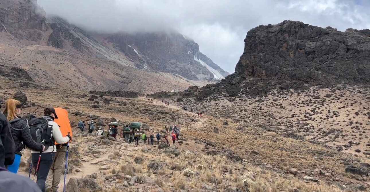
The Lemosho Route crosses the western side of
Kilimanjaro before joining the southern circuit. A
typical progression includes the Lemosho starting
area, Shira Plateau, Barranco, Karanga, Barafu,
Uhuru Peak and the Mweka descent.
Lemosho Route Day-by-Day Progression
The exact overnight sequence depends on whether you
choose the 7-day or 8-day itinerary and on the
operating schedule used for the climb. The following
stages explain the main progression of the route.
01
Lemosho Starting Area to Forest Camp
The trek begins on the western side of
Kilimanjaro and enters the montane forest.
The first stage introduces the gradual
ascent and establishes the rhythm for the
days ahead.
02
Forest to Shira Plateau
The route climbs out of the forest into
the heath and moorland environment before
reaching the broad Shira Plateau.
03
Shira Plateau
The Shira area provides an important
transition to higher elevation. Depending
on the itinerary, the climb can include
additional time around the plateau before
continuing toward the southern circuit.
04
Shira to Barranco
The route moves through increasingly
high-altitude terrain toward Lava Tower
and then descends toward the Barranco
area. This pattern of climbing higher and
sleeping lower is an important part of the
route’s altitude progression.
05
Barranco to Karanga
The trail continues across the southern
side of the mountain. Climbers negotiate
the Barranco section before continuing
toward Karanga Camp.
06
Karanga to Barafu
The route climbs toward Barafu, the high
camp used before the summit attempt.
Climbers prepare their equipment and rest
before the demanding summit section.
07
Barafu to Uhuru Peak
The summit attempt normally begins during
the night or very early morning. Climbers
ascend toward Stella Point and continue
along the crater rim toward Uhuru Peak.
08
Summit Descent to Mweka
After the summit attempt, the route
descends toward the Mweka side of
Kilimanjaro. The descent continues through
progressively lower environments before
reaching the final mountain gate.
Lemosho Route Camps
Lemosho is a camping route, and overnight locations
are an important part of understanding the climb.
Camp names and the exact sequence can vary according
to the selected itinerary and mountain operating
conditions.
Forest Camp
Lower mountain camping area within the forest
zone.
Shira Camp
High-altitude camping area associated with the
Shira Plateau.
Barranco Camp
Southern Circuit camp below the Barranco Wall.
Karanga Camp
High camp used during the approach toward
Barafu.
Barafu Camp
High camp used before the summit attempt.
Mweka Camp
Descent-side camp used after the summit.
Lemosho Route Ecological Zones
One of the major attractions of climbing Kilimanjaro
is the dramatic change in landscape with increasing
elevation. The Lemosho Route crosses several
ecological environments during the ascent.
Montane Forest
The lower section passes through a greener,
more sheltered forest environment with
substantial vegetation.
Heath and Moorland
As the route gains elevation, the forest gives
way to more open terrain and distinctive
highland vegetation.
Shira Plateau
The broad Shira landscape provides a dramatic
high-altitude setting and views toward the
upper mountain.
Alpine Desert
Vegetation becomes sparse as the trail enters
the exposed high mountain environment.
Arctic Summit Zone
Near Uhuru Peak, conditions are cold and
exposed, with very limited vegetation.
Lemosho Route Altitude and Acclimatization
Altitude is one of the most important considerations
when planning a Lemosho Route climb. Uhuru Peak stands
at approximately 5,895 metres above sea level, which
means the summit environment is very different from
the lower mountain.
As elevation increases, atmospheric pressure decreases
and the body receives less available oxygen. A climb
therefore requires an appropriate pace and enough time
for the body to adjust.
Why the 8-Day Lemosho Route Provides More Time
The 8-day Lemosho itinerary adds time to the
mountain schedule compared with the 7-day option.
This can allow the ascent to be spread across a
longer period and provides additional opportunity
for acclimatization.
The exact acclimatization strategy depends on the
itinerary, mountain conditions and decisions made
by the professional mountain crew.
Altitude Symptoms
Climbers can experience symptoms associated with
altitude, including headache, reduced appetite,
tiredness, nausea or disturbed sleep. Any concerning
symptoms should be reported to the mountain guide
immediately.
Climbers should never hide symptoms simply to continue
toward the summit. The mountain crew should assess the
situation and make decisions based on the climber’s
condition and prevailing mountain circumstances.
How Difficult Is the Lemosho Route?
The Lemosho Route is a challenging high-altitude trek
rather than a technical mountaineering climb. It
requires sustained walking over several days, camping
at increasing elevations and completing a demanding
summit ascent.
The western approach itself is not a reason to assume
the climb is easy. The highest sections of the route
involve cold, thin air, steep terrain and long hiking
days.
Physical Preparation
-
Build regular cardiovascular endurance before the
climb. - Include long walks and uphill training.
-
Train with a backpack similar to your expected
daypack. - Break in your trekking boots before departure.
- Prepare for several consecutive days of hiking.
- Include recovery and rest as part of your training.
Best Time to Climb the Lemosho Route
Mount Kilimanjaro can be climbed during different
periods of the year, but many trekkers prefer the
generally drier seasons because of the combination of
trail conditions and mountain weather.
January to March
January through March is one of the commonly used
periods for Kilimanjaro trekking. Conditions can be
suitable for climbing, although weather can still
change quickly at higher elevations.
June to October
June through October coincides with a major dry-season
period and is another commonly used period for
Kilimanjaro climbs.
Wetter Periods
Rain and snow can occur outside the drier periods.
Climbers should therefore carry suitable waterproof
protection and warm layers regardless of the month
selected.
Lemosho Route Weather
Kilimanjaro weather changes significantly with
elevation. A trek can begin in relatively warm
conditions in the lower forest and finish in freezing
conditions near Uhuru Peak.